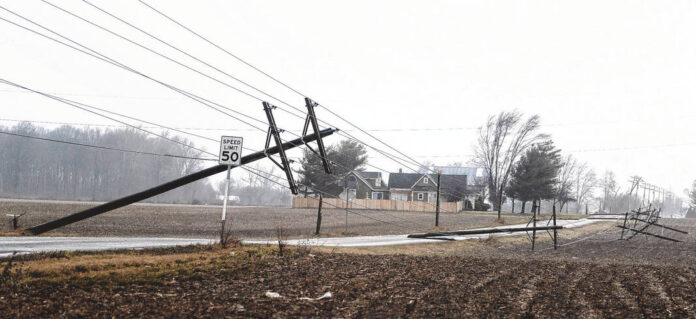
HANCOCK COUNTY — Officials from the Hancock County Emergency Center and the National Weather Service hit the ground running Tuesday morning to assess storm damage from Monday afternoon.
The group gathered in the southwestern part of the county to determine if a tornado did strike during the tornado warning around 1:33 p.m. Monday, Feb. 27.
Misty Moore, director of the Hancock County Emergency Management Center, noted officials from the NWS visited, among several stops, the 130-year-old Kingen Round Barn, 4682 W 600 N, McCordsville, near CR West 600N.
“The National Weather Service definitely believes it was a tornado,” Moore said. “They’re thinking it was an F-1 or a lower level F-2.”
That means winds of at least 86 to 110 mph (EF-1) or possibly more up to 135 mph (EF-2) ripped through the area.
“Officials said the tornado didn’t just touch down and keep going through, but it popped back up and touched down over several locations,” Moore said. “The damage was so sporadic.”
The assessment continued most of Tuesday morning as officials also visited a collapsed barn on Ind. 9 after they looked over everything at the Kingen Round Barn. From snapped utility poles with wires down, collapsed structures and at least one blown-over box truck, the winds were powerful enough to indicate a tornado did hit the county.
“We talked to several home owners who had actual pictures of the funnel cloud,” Moore said.
Officials in the county took many emergency reports during the quick-moving storm, some stating the storm was more than high winds and rain.
Officials noted in one report from a business in the 5600 block of Aurora Way, McCordsville, that they believed the building was hit by a tornado. Officials on the scene observed heavy damage to the southwestern roof section of the building, but said there were no injuries.
During the storm, law enforcement in the Fortville area reported at the time a tornado hit the area located on West Ind. 234 and the North Fortville Pike. That’s where the driver of a box truck told officials he was stopped at a stop sign when wind tipped his truck over. Officials noted that no one was injured there either.
With spring rapidly approaching, officials note Monday’s storm is a great example as to why everyone should know the differences between a tornado watch and warning and should take both seriously.
A tornado watch means to be prepared. The NWS issued a tornado warning from 11 a.m. to 4 p.m. Monday for Central Indiana. That meant tornadoes were possible in and near the watch area.
Officials say when a tornado watch is issued, it’s a great time to review and discuss emergency plans and check supplies and to have a safe room.
“Acting early helps to save lives,” officials from the NWS said on their website.
Watches are issued by the NWS Storm Prediction Center for counties where tornadoes may occur. The watch area is typically large, covering numerous counties or even states, as was the case Monday.
A tornado warning is different from the watch and means people need to take action right away because a tornado has been sighted or indicated by weather radar. In other words, there is imminent danger to life and property. When the warning comes, people need to move to an interior room on the lowest floor of a sturdy building and avoid windows.
For those living in a mobile home, a vehicle or outdoor area, they need to move to the closest substantial shelter and protect themselves from flying debris. Warnings are issued by a local forecast office.
Warnings typically encompass a much smaller area than a watch (around the size of a city or county) which may be impacted by a tornado identified by a forecaster on radar or by a trained spotter or law enforcement who is watching the storm as it comes through.
“We want to remind people if they hear the siren they need to act and seek shelter immediately,” Moore said. “If there is a warning or someone spots a funnel cloud, that’s when we set off the sirens. They will never be set off just for a tornado watch.”
Moore noted Monday’s storm jumped from a watch to a warning around 1:33 p.m. That was right after area sirens went off throughout the county.
Moore noted the tornado hitting in February was earlier than she can ever recall, but that the warmer weather meant it was possible.
“This was definitely before anyone had tornado’s on their radar,” Moore said. “But, everyone took the sirens seriously and we had zero injuries.”


