

CUMBERLAND – Right now, it’s mostly undeveloped land at a corner of two thoroughfares on Hancock County’s ever-growing west side.
But in the coming years, it could be an expanse of homes, businesses and outdoor amenities, as outlined in a master development plan leaders in Cumberland are creating.
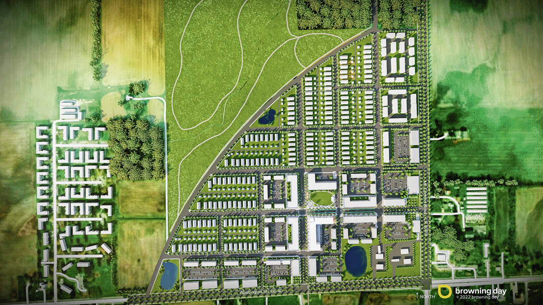
The area is located near the northwest corner of U.S. 40 and Mt. Comfort Road. Officials are working on a strategy for land there the town has control over, including how to fund infrastructure and draw developers. They’re establishing a vision for how they’d like to see the surrounding acreage develop as well.
About 250 acres make up the overall location, where the town has goals for people-focused, live-work-play-stay neighborhoods that are walkable and include trails. Retail, offices, medical offices and a mix of housing including apartments, townhomes and single-family homes are also among the objectives, as well as public gathering green spaces.
The Cumberland Community Development Corporation, a nonprofit organization, bought over 31 acres near the northwest corner of U.S. 40 and Mt. Comfort Road earlier this year for nearly $1.9 million with funds granted by the Cumberland Redevelopment Commission.
“We’ve master-planned, if you will, 200, 250 acres, so while our focus and detail is really on that section one, we’ve looked at that larger picture so we understand how it connects into the community,” Cumberland assistant town manager Christine Owens said at a redevelopment commission meeting earlier this week. “And as those other areas develop, then we have a plan for that and how we want to see that develop.”
Avon-based Landmark Petroleum LLC owns the nearly 4 ¼ acres right at the corner of the intersection, which town leaders hope will draw a use complementary to their vision.
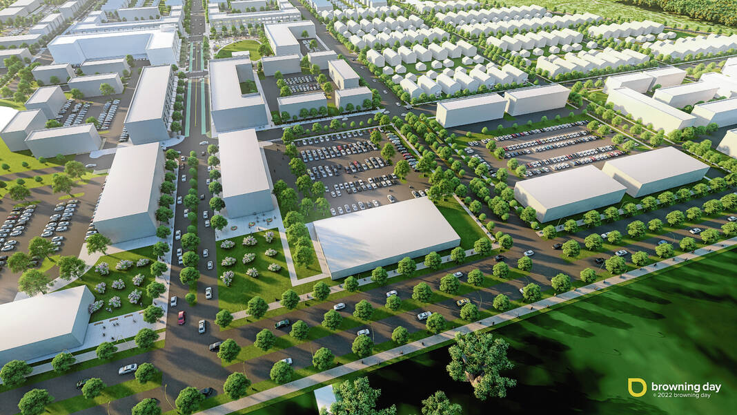
Plans for the community development corporation’s 31 acres call for buildings housing offices, retail, medical offices and multi-family housing. Current contemplations total 226 apartments, 23 townhomes, 34,500 square feet of retail space, 75,600 square feet of medical office space and over 43,000 square feet of office/commercial/retail space.
In conceptual illustrations prepared for the town, medians filled with trees and landscaping line U.S. 40, Mt. Comfort Road and entrances into the development. Trails would flank the thoroughfares, and bike lanes are envisioned throughout the site too. A pocket park could include a water feature and performance area, and a trail connection could span south to the Pennsy Trail.


Drew Braley of Browning Day, an Indianapolis architecture firm assisting Cumberland, emphasized the plans are not final.
“We’ve got a lot of work here, we’ve come a long way,” Braley said. “It’s still a fluid plan. There are still things we’re going to change; we’re not building this tomorrow.”
That’s reflected in the way the buildings are depicted in the renderings, Owens said.
“We didn’t want to get hung up on the architecture of the buildings because as things develop, the market’s going to drive a lot of that, so that’s why they’re kind of white,” she said. “But the form is there, the massing is there, the scale is there, and those are really the important things that we’re master-planning.”
The overall area Cumberland is eyeing includes a floodplain to the north, prompting thoughts of creating an outdoor amenity, as constructing buildings would be hampered there. Long-term, leaders are also thinking about how to connect the overall development to Eastway Court Apartments to the west, which is growing to the north, as well as the Parkview Village neighborhood coming to the west of that.
Adam Stone, a financial advisor with Greenwood-based Stone Municipal Group assisting the Cumberland Redevelopment Commission, prepared figures for the development’s first phase based on how it is sketched using current assessed valuations. Those, he said, would become the platform for any negotiations over public-private partnerships the town may pursue for any parts of the development.
“Certainly you can then toggle up or toggle down based on what actually gets brought into the project,” he told commission members.
Stone estimates the developments that are part of the first 31-acre phase would reach a total net assessed value of over $55 million.
“And I actually think that’s probably a little bit on the conservative side,” he added.
He echoed sentiments regarding parts of the plan being subject to change, adding it’s unlikely a single developer would take on all of the objectives desired.
Stone also estimates annual revenue from taxes generated by the first-phase developments to be almost $1.4 million, which could go toward paying off debts for infrastructure the redevelopment commission could take on for the location. Total infrastructure costs come in at almost $14.5 million, he estimates.


